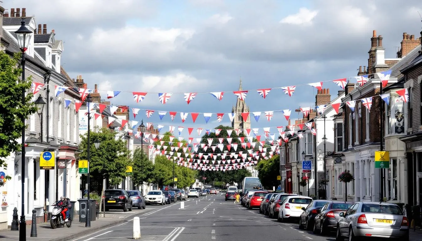
Walking down Shankill Road in west belfast, the union flags and loyalist murals immediately signal you’ve entered one of northern ireland’s most historically significant streets. This predominantly protestant working-class community has been shaped by centuries of history, from ancient church origins to its notorious role during The Troubles, making it an essential destination for understanding Belfast’s complex past and present.
Stretching 1.5 miles from the city centre through some of belfast’s most politically charged neighborhoods, shankill road represents both the deep roots of Ulster loyalism and the ongoing legacy of sectarian conflict. Whether you’re interested in political history, dark tourism, or simply understanding modern northern ireland, this comprehensive guide covers everything you need to know about visiting and understanding this iconic street.
What is Shankill Road Belfast
Shankill Road serves as a major 1.5-mile thoroughfare running west from belfast city centre through a predominantly loyalist working-class area that has become synonymous with Ulster Unionist identity. The road’s name derives from the irish “Seanchill,” meaning “old church,” referencing an ancient ecclesiastical site dating back to 455 AD when a settlement formed around st patrick’s Church of the White Ford.
Today, the shankill is instantly recognisable by its abundant union flags, red-white-blue bunting, and loyalist murals honoring the Royal Family and local history. These visual displays of British identity mark the area as a stronghold of Protestant unionism, where residents maintain fierce loyalty to the crown and Northern Ireland’s place within the United Kingdom.
The road gained worldwide notoriety as an epicenter of violence during The Troubles, with both the ulster volunteer force (UVF) and ulster defence association (UDA) maintaining significant paramilitary activity throughout the conflict. Despite the peace process, the shankill area remains one of belfast’s most politically sensitive neighborhoods, separated from the catholic falls road by a massive peace wall that has stood for over 50 years.
Historical Development of Shankill Road
The ancient origins of shankill road trace back over 1,500 years to its role as a pilgrimage site centered around st patrick’s Church of the White Ford, with only the historic graveyard remaining today as a testament to this early christian heritage. Archaeological evidence suggests the original old church was established around 455 AD, making it one of belfast’s oldest continuously inhabited areas and a significant religious center in early medieval Ulster.
The transformation from rural pilgrimage route to urban thoroughfare began during the 19th-century expansion driven by the linen industry boom that made belfast the world’s linen capital by the late 1800s. The bóthar na seanchille, as it was known in irish seanchill, became a main road connecting the growing city with County Antrim, facilitating the movement of workers and goods that fueled Belfast’s industrial revolution.
Major employment opportunities came from Harland & Wolff shipyard, which provided jobs for thousands of shankill residents and established the area’s reputation as a loyalist working-class stronghold. The shipyard’s prominence during both world wars cemented the community’s British identity, with many local men serving in the 36th (Ulster) Division and forming lasting connections to crown and country that persist today.
However, the 20th-century decline began with industrial collapse in the post-war period, leading to high unemployment and social problems that created fertile ground for paramilitary recruitment. As traditional industries like linen manufacturing and shipbuilding declined, the shankill area faced economic hardship that contributed to the community tensions that would explode during The Troubles.
The Troubles Era and Paramilitary Activity
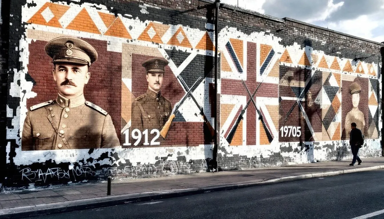
The modern incarnation of The Troubles on shankill road began with the formation of the ulster volunteer force in 1912 as a militant organization opposing Irish Home Rule, but it was the group’s reformation in 1966 that marked the beginning of three decades of sustained violence. The reformed UVF’s first attack came with a petrol bombing of a catholic owned pub, signaling the start of systematic sectarian violence that would define the area for generations.
In 1971, the ulster defence association established its headquarters on shankill road, creating a parallel loyalist paramilitary structure that competed with the UVF for influence while cooperating in the broader campaign against irish republican forces. The UDA’s C Company became particularly notorious for its brutal tactics and maintained control over significant portions of the shankill area throughout the conflict.
The most infamous period came with the shankill butchers operation from 1975-1982, when a UVF unit led by Lenny Murphy killed at least 23 people in brutal sectarian attacks that shocked even hardened observers of The Troubles. Operating primarily at night during their reign of terror, the butchers targeted random catholics in a campaign designed to spread fear throughout nationalist communities across belfast.
Major Violent Incidents
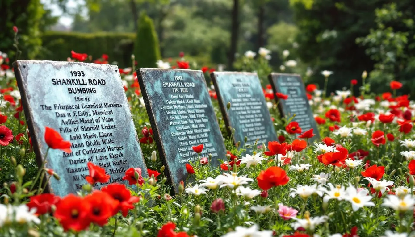
The 1993 shankill road bombing at frizzell’s fish shop remains one of The Troubles’ most devastating attacks, killing eight innocent protestant civilians when an IRA bomb exploded prematurely during an assassination attempt against UDA leadership. The attack, intended to kill senior loyalists meeting above the chip shop, instead claimed the lives of ordinary shoppers and workers, including two children, demonstrating how the conflict’s violence often struck hardest at innocent civilians.
Previous attacks included the Bayardo Bar bombing in 1975, which killed five protestant civilians and remains commemorated through memorials featuring formal and informal plaques condemning IRA terrorism. The attack targeted a pub frequented by loyalists, but like many incidents during The Troubles, the victims were primarily ordinary working people caught in the crossfire of sectarian violence.
Multiple pub bombings throughout the 1970s and 1980s targeted establishments including the Berlin Arms, Windsor Bar, and Long Bar (now disappeared), creating an atmosphere of constant fear that fundamentally changed community life on shankill road. These attacks forced residents to be constantly vigilant, leading to the installation of security measures and the development of informal networks to share information about potential threats.
The murder of john scullion in May 1966 marked the first modern UVF victim, shot outside his west belfast home in an attack that many historians consider the unofficial beginning of The Troubles. Scullion’s death demonstrated how the conflict would primarily victimize working-class people on both sides, establishing a pattern of sectarian violence that would claim over 3,500 lives over the following three decades.
Geography and Districts of Shankill Road
The lower shankill area, known locally as “The Hammer,” begins at Peter’s Hill near belfast city centre and represents the most densely populated section of the community. This area houses some of the most significant loyalist murals and serves as the symbolic heart of the community, with easy access to central belfast making it a natural starting point for visitors exploring the district.
Peace line gates at Townsend and northumberland street provide controlled access points connecting to crumlin road and falls road, though these crossings remain heavily monitored and occasionally closed during periods of heightened tension. The gates represent both the physical and psychological barriers that continue to divide belfast communities more than two decades after the Good Friday Agreement.
Community facilities throughout the lower shankill include Shankill Leisure Centre, the Shankill Women’s Centre, and various redevelopment projects aimed at improving living conditions in this historically deprived area. Despite ongoing challenges, these facilities provide essential services and represent community efforts to build positive alternatives to the area’s troubled past.
The district also serves as the historical stronghold of the UDA’s C Company, commemorated in local murals and community spaces that honor both fallen paramilitaries and ordinary residents who endured decades of conflict. These commemorations remain controversial but represent genuine community memory and identity that visitors should understand rather than judge.
Middle and Upper Shankill Areas
The area above Agnes street features several protestant churches including West Kirk Presbyterian and Shankill Methodist, reflecting the strong religious identity that has long characterized the community. These churches played crucial roles during The Troubles, often serving as community centers and sources of support during the darkest periods of violence.
The west belfast orange hall stands as a key community landmark, hosting Orange Order meetings and cultural events that maintain the area’s connection to Ulster Protestant traditions. The hall represents the institutional framework that has preserved loyalist culture and provided community leadership throughout periods of political upheaval.
Historic shankill cemetery serves as one of belfast’s oldest burial grounds, with gravestones dating back centuries and providing a tangible connection to the area’s ancient heritage. The cemetery includes graves of many prominent community figures and ordinary residents whose lives spanned the transition from rural pilgrimage site to urban battleground.
The lanark way connection to the nationalist Springfield Road features gates that close at night, maintaining separation between communities that have struggled to build trust despite peace agreements. This controlled access point symbolizes the ongoing challenges facing integration efforts and the persistence of community divisions that predate The Troubles by centuries.
The rex bar remains one of the oldest establishments on the road, while the Brown Bear pub gained notoriety as a former meeting place for the shankill butchers before being demolished and rebuilt. These venues represent both the continuity of community life and the attempts to move beyond the violent associations that once defined the area.
Greater Shankill Community
The broader community encompasses approximately 22,000 residents spread across areas including Woodvale, Glencairn, and Highfield estates, representing one of northern ireland’s largest concentrated loyalist populations. This extended community shares cultural identity and political loyalties while facing common challenges related to economic deprivation and ongoing social problems.
The area maintains a rich sporting heritage with several football clubs and community organizations serving diverse needs across different age groups. Additionally, integrated schools in the broader area work to serve students from various backgrounds, representing hopeful signs of progress toward community reconciliation.
Political representation within Belfast West constituencies reflects the complex dynamics of northern ireland politics, where community leaders must balance traditional loyalties with practical needs for economic development and social progress. These representatives often walk a difficult line between maintaining community identity and building bridges across sectarian divides.
Close-knit street networks throughout the shankill reflect working-class community bonds and shared history that extend back generations, creating social structures that provided resilience during The Troubles but also resistance to change. Understanding these community dynamics is essential for visitors seeking to comprehend the area’s complex social and political landscape.
Murals and Memorials
UVF and UDA commemorative murals feature prominent loyalist figures like jackie coulter and William McCullough, serving as both artistic expressions and political statements that assert community identity and honor fallen members. These murals often include detailed biographical information and symbolic imagery that tells the story of loyalist resistance during The Troubles from the community’s perspective.
Tributes to Hugh Smyth and Glasgow Rangers football club reflect broader community loyalties that extend beyond purely political concerns to encompass cultural and sporting affiliations that strengthen bonds within the loyalist community. The Rangers connection, in particular, demonstrates how Scottish Protestant identity influences Ulster loyalism and provides cultural bridges beyond northern ireland.
The shankill road Memorial Garden honors WW1 and WW2 soldiers alongside victims of the 1993 bombing, creating a space where community grief and pride intersect in complex ways. The memorial serves multiple functions: commemorating military service, mourning innocent victims, and asserting the community’s British identity through its emphasis on crown service.
hopewell crescent murals demonstrate the evolution from militant imagery to positive community messages, reflecting broader changes in loyalist political expression following the peace process. These newer murals often emphasize community pride, cultural heritage, and positive role models rather than purely military or paramilitary themes, suggesting evolving approaches to political expression.
Peace Wall and Modern Boundaries
The british army constructed the peace wall along Cupar Way in 1969 following violent sectarian clashes that threatened to spiral into full-scale urban warfare. Originally intended as a temporary measure to separate combating communities, the wall has become a permanent feature of belfast’s landscape and a stark reminder of the city’s divided nature.
This massive barrier creates permanent separation from the catholic falls road area, extending over several miles and reaching heights of up to 25 feet in some sections. The wall includes various gates and checkpoints that allow controlled movement between communities, but these access points often close at night and during periods of heightened tension.
Despite the 1998 Good Friday Agreement and ceasefires declared by major paramilitary organizations in the mid-1990s, ongoing community tensions ensure that the peace wall remains necessary for maintaining order. Incidents of stone-throwing, petrol bombing, and other low-level violence continue to occur, particularly during sensitive periods like marching season or political anniversaries.
The gates and checkpoints maintain distinct community identities while providing controlled access that allows some level of interaction between previously isolated populations. However, these barriers also reinforce segregation and limit the natural integration that might otherwise occur in a normal urban environment, creating ongoing challenges for peace-building efforts.
Visiting Shankill Road Today
guided political walking tours lasting approximately 3 hours cover both shankill and falls road areas, providing comprehensive historical context and balanced perspectives on The Troubles from experienced local guides. These tours typically cost between £15-25 per person and offer the most educational approach to understanding the complex political and social dynamics that shaped both communities.
Black Taxi Tours represent another popular option, costing around £20+ per person and providing local driver perspectives along with historical explanations as you travel between key sites. These tours offer more personalized experiences and often include drivers who lived through The Troubles, providing firsthand accounts that add depth to the historical narrative.
Independent exploration remains possible during daylight hours with basic safety precautions and cultural awareness, allowing budget-conscious visitors to see the murals and memorials at their own pace. However, visitors should be respectful of the fact that this remains a living community where people go about their daily lives, rather than simply a tourist attraction.
Online booking is strongly recommended for guided tours to secure places and ensure access to detailed historical explanations from knowledgeable guides. Popular tour companies often fill up, particularly during summer months when tourist numbers peak, making advance planning essential for optimal experiences.
Safety and Access Information
Daytime visits are generally safe for tourists who exercise basic precautions and maintain awareness of their surroundings, though visitors should avoid displaying obvious political symbols or engaging in provocative behavior. The community is accustomed to tourists and generally tolerates respectful visitors, but sensitivity to local feelings remains important.
Late night visits are strongly discouraged due to ongoing community sensitivities and the potential for alcohol-related incidents that could escalate unexpectedly. The area’s pubs and social clubs can become flashpoints during sensitive periods, making evening visits potentially problematic for outsiders unfamiliar with local dynamics.
Free access allows independent exploration of murals and memorial sites throughout most areas of shankill road, though visitors should be prepared for occasionally encountering locked gates or restricted areas during sensitive periods. Most major sites remain accessible to the public, but some locations may require permission or guided access.
Enhanced understanding comes through guided tours rather than self-guided visits, as experienced guides can provide crucial context about the historical events, political dynamics, and community perspectives that shaped the area. Without this background knowledge, many visitors miss the nuanced meanings behind murals, memorials, and community symbols.
Key Locations and Coordinates
Notable mural locations concentrate north of the northumberland street gate at the peace wall (coordinates: 54.6015, -5.9471), where some of the most significant loyalist artwork commemorates key figures and events from Belfast murals. This area provides easy access for photographers while remaining respectful of community sensitivities.
The district borders with falls road, crumlin road, and hopewell crescent areas create natural touring routes that allow visitors to understand the geographic context of community divisions. These boundaries often feature the most dramatic murals and political displays, making them essential stops for comprehensive understanding.
Connection points to central belfast via Peter’s Hill provide convenient access from the city centre, making shankill road easily reachable for day visitors staying in downtown hotels. Public transportation and walking routes allow budget-conscious exploration while taxi services offer more comfort and local insights.
lanark way serves as a controlled access point between loyalist and nationalist communities, offering visitors a chance to see the physical barriers that continue to divide belfast neighborhoods. This location provides stark visual evidence of ongoing segregation and the challenges facing peace-building efforts in post-conflict northern ireland.
Cultural and Tourism Significance
Shankill road has emerged as a major dark tourism destination, attracting international visitors interested in conflict history and the legacy of political violence in western Europe. The area’s authentic preservation of Troubles-era murals and memorials provides unprecedented access to community memory and political expression that remains rare in post-conflict societies.
The natural combination with Republican falls road offers visitors balanced perspectives on The Troubles, allowing them to understand how both communities experienced and remember the conflict differently. This comparative approach provides more nuanced understanding than visiting either area alone, helping visitors appreciate the complexity of northern ireland’s divided society.
Links to crumlin road Gaol create opportunities for comprehensive west belfast historical experiences that trace the area’s story from ancient origins through industrial development to modern conflict and peace-building efforts. These combined attractions allow visitors to spend full days exploring interconnected aspects of belfast’s troubled but fascinating history.
The area appeals primarily to political history enthusiasts and dark tourism visitors rather than mainstream belfast tourists, creating a specialized niche that attracts educated, internationally-minded travelers seeking deeper understanding of conflict and reconciliation. This audience appreciates authentic experiences over sanitized tourist attractions, making shankill road’s unvarnished presentation of community memory particularly valuable.
Shankill road stands as one of northern ireland’s most significant historical and cultural sites, offering visitors unparalleled insights into the loyalist community’s experience of The Troubles and their ongoing struggle to maintain identity while building peace. Whether you’re interested in political history, community resilience, or the complex legacy of sectarian conflict, this iconic street provides essential understanding of modern belfast and the challenges facing divided societies worldwide.
For the most rewarding experience, book a guided tour that covers both shankill road and falls road, allowing you to understand multiple perspectives on northern ireland’s complex history. While in Northern Ireland, consider exploring Fairhead, a stunning coastal destination known for its dramatic cliffs and scenic hiking trails. Remember that you’re visiting a living community with deep historical wounds, so approach with respect, curiosity, and an open mind to the lessons this remarkable place has to offer.
