Standing on the windswept cliffs of Torr Head Ballycastle, you’re closer to Scotland than anywhere else in Ireland. Just 12 miles of churning North Channel waters separate this dramatic rocky headland from the Scottish Mull of Kintyre, making it one of Northern Ireland’s most geographically significant and visually spectacular destinations. Along the same stunning coastline, be sure to visit Ballintoy Harbour on the Causeway Coast, renowned for its breathtaking beauty.
This rugged outcrop, located three miles east of Ballycastle in County Antrim, offers visitors a unique combination of breathtaking coastal scenery, fascinating maritime history, and ancient Celtic heritage. Whether you’re drawn by the panoramic views of Scotland, the ruins of a 19th-century signal station, or the chance to drive one of Ireland’s most scenic coastal routes, Torr Head delivers an unforgettable experience that showcases the raw beauty of the antrim coast.
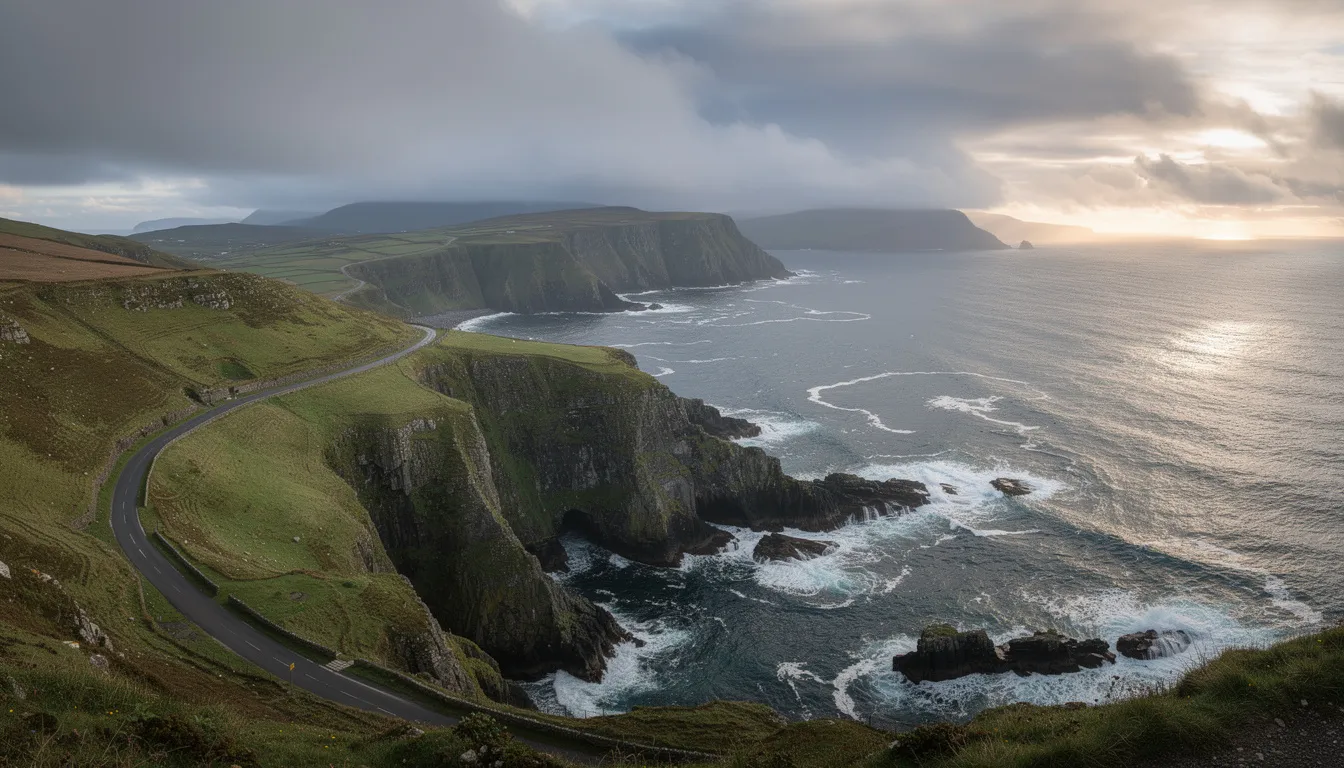
The journey to reach this remote headland is an adventure in itself, taking you along the narrow, winding torr head scenic route that connects Ballycastle and Cushendun through some of Northern Ireland’s most stunning countryside.
What is Torr Head
Torr Head stands as the closest point between Northern Ireland and Scotland, positioned just 12 miles across the north channel from the Mull of Kintyre. This strategic location has made it historically significant for centuries, serving as a crucial communication link between Ireland and Scotland.
Located 3 miles east of Ballycastle Ballycastle in County Antrim, this dramatic rocky headland offers panoramic views of Scotland that are unmatched anywhere else in ireland. On a clear day, visitors can easily spot the distinctive outline of the Scottish coast, making it feel as though you could almost reach across and touch another country.
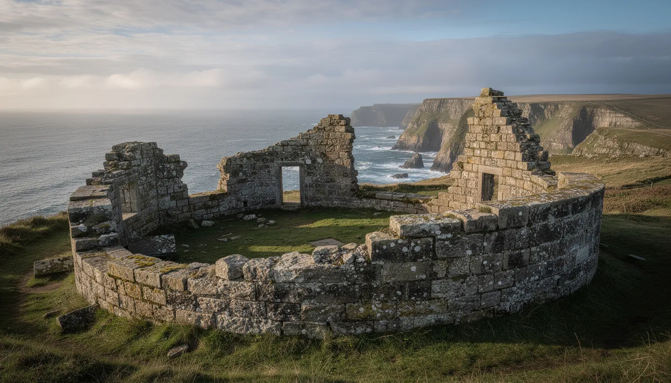
The site features the ruins of a 19th-century Lloyd’s Signal Station that once relayed transatlantic shipping information to London via a sophisticated communication system. This coastguard station played a vital role in maritime safety and commerce, monitoring vessels as they passed through these busy waters between ireland and Scotland.
Torr Head forms part of the 21.7km torr head scenic route connecting Ballycastle and Cushendun, a journey that takes visitors through rolling hills, ancient stone walls, and some of the most spectacular coastal scenery in Northern Ireland. The entire route winds through countryside that perfectly captures the essence of County Antrim’s natural beauty.
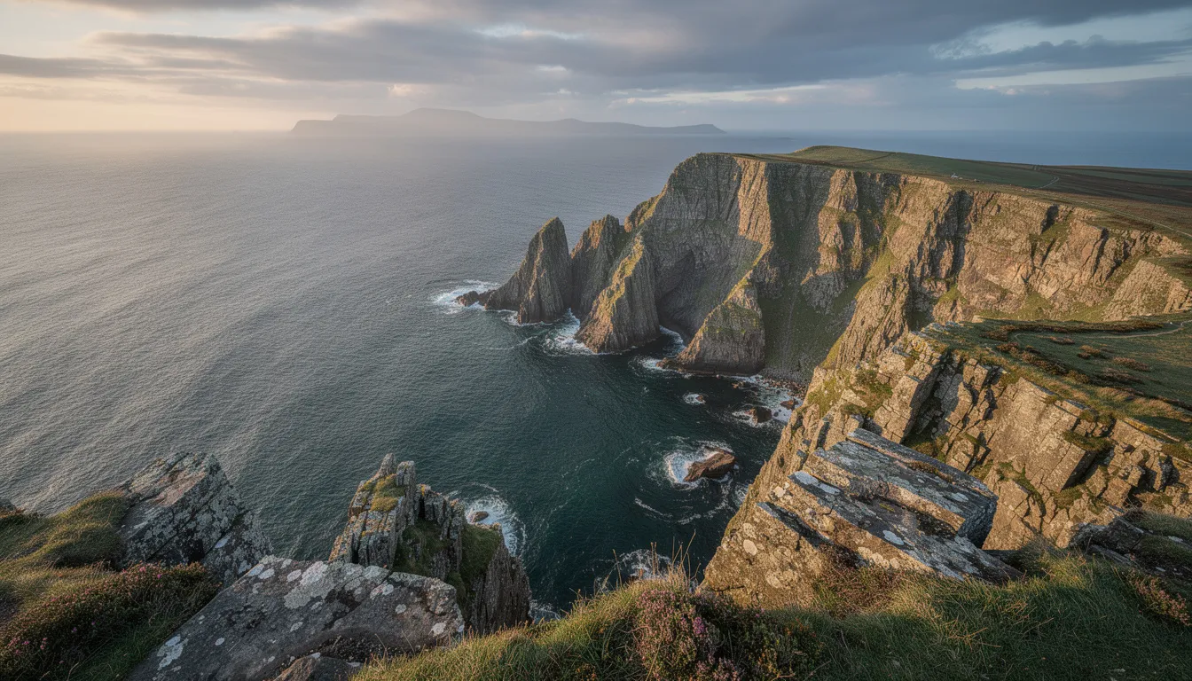
As part of the Antrim Coast & Glens Area of Outstanding Natural Beauty, Torr Head is protected for its exceptional landscape value and geological significance. The headland showcases unique rock formations that tell the story of Ireland’s ancient geological past, with metamorphosed limestone and volcanic rock sequences clearly visible to those interested in the area’s natural history.
Getting to Torr Head
Access to Torr Head requires navigating the narrow, winding torr head scenic route marked with distinctive brown signage reading ‘Torr Head Scenic Route’ in white lettering. This carefully marked route ensures visitors can find their way along what can sometimes be challenging terrain.
The drive from Ballycastle takes approximately 20 minutes along bendy coastal roads that offer spectacular views at every turn. However, these aren’t your typical highway conditions – the route demands careful attention and patience as it winds through the countryside with numerous blind spots and narrow passages.
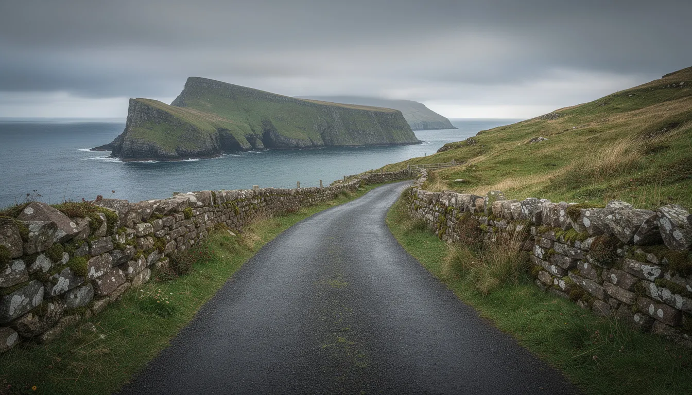
A steep descent leads visitors down to a small car park near the historic coastguard station ruins. This parking area provides convenient access to the main attractions, though space is limited and fills quickly during peak summer months when visibility is clear and conditions are favorable.
Important vehicle restrictions apply: The route is entirely unsuitable for large vehicles, coaches, caravans, and most campervans due to the narrow road width and sharp turns. These restrictions aren’t suggestions – attempting to navigate larger vehicles along this route can result in serious difficulties and potential damage.
Weather conditions play a crucial role in safely accessing Torr Head. Visitors should always check conditions before traveling, as mist and fog can severely reduce visibility on elevated sections of the route. The exposed location means weather can change rapidly, turning a clear, beautiful drive into a challenging navigation exercise within minutes.
The complete journey along the scenic route offers multiple stopping points and viewpoints, but reaching Torr Head itself requires commitment to the full descent. Once you begin the final approach, turning around becomes difficult until you reach the designated parking area at the bottom.
What to See and Do at Torr Head
The primary attraction at Torr Head is undoubtedly the spectacular views of the Mull of Kintyre, Rathlin Island, and the Scottish coastline on clear days. These panoramic vistas provide some of the most dramatic coastal photography opportunities in Northern Ireland, with the ever-changing light conditions creating different moods throughout the day.
Visitors can explore the fascinating ruins of the 1822 Lloyd’s Signal Station, enclosed by distinctive circular stone walls that have withstood nearly two centuries of Atlantic weather. These substantial remains tell the story of international maritime commerce and the sophisticated communication networks that once operated from this remote location.
A short walk leads to the hilltop viewpoint, offering panoramic sea and landscape photography opportunities that capture the dramatic meeting point between land and sea. This elevated position provides the best vantage point for understanding the geographical significance of Torr Head’s location.
The site contains numerous ancient walls and ruins beyond the signal station, including remnants of the sixth-century Altagore cashel. These archaeological features demonstrate the long history of human settlement at this strategically important location, where people have watched the sea for over 1,500 years.
Geological enthusiasts will appreciate the unique rock formations showcasing metamorphosed limestone and volcanic rock sequences. These formations provide excellent examples of the geological processes that shaped both ireland and Scotland, with clear evidence of the ancient connections between these now-separated lands.
A fresh water well, located in the garden area of the former coastguard station, remains accessible to visitors and demonstrates the practical considerations that made long-term occupation of this remote headland possible. This well has likely provided water to inhabitants for centuries.
The exposed nature of the headland creates excellent conditions for observing weather patterns and sea conditions. Visitors often spend considerable time simply watching the interplay of light, clouds, and sea that makes this location so photogenic and memorable.
History and Legends of Torr Head
Ancient History
Long before recorded history, Torr Head served as the site of Dún Bharraigh (Dunworry), an ancient Celtic cashel known as the Citadel of Barach the Great. This fortified settlement controlled one of the most strategic points along the Irish coast, overlooking the narrow waters that separate ireland from Scotland.
The location connects deeply to Irish mythology through the tragic legend of Deirdre of the Sorrows, one of Ireland’s most enduring tales of love and betrayal. According to legend, this headland played a role in the conspiracy involving Baruch the Great and King Conchur Mac Nessa against Naoise and his brothers.
These ancient stories aren’t merely folklore – they reflect the real strategic importance of Torr Head as a signaling point between ireland and Scotland. For centuries, this elevated position allowed communication across the north channel, whether for trade, military purposes, or simply maintaining contact between related communities on both sides of the water.
Archaeological evidence suggests continuous occupation of the headland from the Celtic period through early Christian times. The sixth-century cashel remains demonstrate sophisticated construction techniques and strategic thinking that allowed communities to thrive in this challenging but advantageous location.
19th Century Maritime Heritage
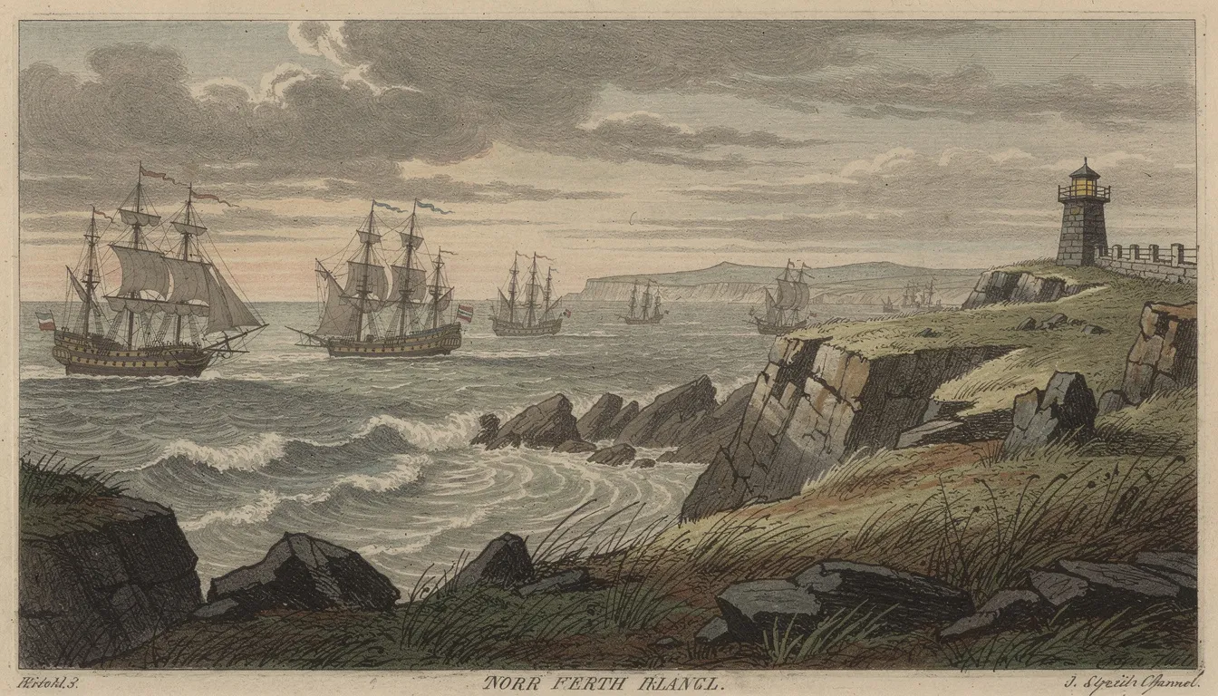
The Lloyd’s Signal Station, established in 1822, transformed Torr Head into a crucial link in international maritime commerce. This sophisticated communication system monitored transatlantic shipping traffic, providing essential information about vessel movements to Lloyd’s of London, the world’s premier maritime insurance market.
Information was relayed via Marconi’s wireless telegraphy system, representing cutting-edge technology of its era. Ships passing through the north channel would be spotted from Torr Head, with their details transmitted to London where insurance companies, shipping agents, and families anxiously awaited news of safe passage.
The coastguard station provided essential monitoring and rescue services for vessels navigating these often treacherous waters. The narrow passage between ireland and Scotland, while offering the shortest route, also presented significant challenges during storms or poor visibility conditions.
This period represents the height of Torr Head’s importance in international commerce. The information transmitted from this remote irish headland directly influenced shipping schedules, insurance rates, and commercial decisions made in major ports across the Atlantic world.
Nearby Attractions and Activities
Along the Scenic Route
Just 20 minutes from Torr Head, Murlough Bay offers additional spectacular scenery and serves as both a Game of Thrones filming location and the burial site of sir roger casement, the famous irish patriot and poet. This sheltered bay provides a completely different perspective on the antrim coast, with its peaceful waters contrasting sharply with Torr Head’s exposed position.
Fair Head Cliffs rise to become Northern Ireland’s tallest cliffs at 196m (643 feet) above sea level, creating one of the most dramatic cliff faces in either ireland or Britain. These towering basalt cliffs provide habitat for seabirds and offer challenging rock climbing opportunities for experienced climbers. If you’re interested in reaching the very highest point in the country, Carrauntoohil, the highest mountain in Ireland, rises to 1,039 meters in scenic County Kerry.
Rock climbing enthusiasts will find over 100 climbing routes across multiple crags at fair head, ranging from beginner-friendly routes to extremely challenging climbs that test even expert climbers. The main crag curves around the headland for 3 kilometers, providing some of the longest and highest-quality climbs available anywhere in the British Isles.
Lough na Cranagh offers trout fishing opportunities during summer months, providing a peaceful contrast to the dramatic coastal scenery. This small lough represents the gentler side of County Antrim’s landscape, surrounded by rolling hills and traditional stone walls.
From Ballycastle
A 25-minute ferry service connects Ballycastle to rathlin island, where visitors can enjoy puffin watching during breeding season and explore additional coastal walks. Rathlin Island provides the closest point to scotland that’s actually accessible by public transport, offering a different perspective on the geographic relationship between ireland and Scotland.
Ballycastle Beach and the town center provide essential services including cafes and restaurants, making it an ideal base for exploring Torr Head and the surrounding area. The town’s location makes it perfect for accessing multiple attractions along the causeway coastal route.
The location provides easy access to other major attractions including Carrick-a-Rede Rope Bridge, the Giant’s Causeway, and Old Bushmills Distillery. These world-famous attractions combine with Torr Head to create a comprehensive exploration of Northern Ireland’s most spectacular coastal region.
Dunluce Castle ruins, perched dramatically on coastal cliffs, add medieval history to any visit to the area. The castle’s precarious position demonstrates the ongoing human fascination with building in spectacular but challenging coastal locations.
Practical Tips for Visiting
Allow approximately 1.5 hours total for your visit, including driving time along the scenic route and adequate time for exploration of Torr Head itself. This timing ensures you can properly appreciate both the journey and the destination without feeling rushed.
The small car park fills quickly during summer months, especially on clear days when visibility is optimal for viewing Scotland. Arriving early in the day or visiting during shoulder seasons can help ensure parking availability and provide better photography conditions.
Weather considerations are crucial for any visit to Torr Head. Always check the weather forecast before departure, as conditions can change rapidly on this exposed headland. Mist and fog can develop quickly, severely limiting visibility and making the narrow access road potentially dangerous.
Safety should be a primary concern throughout your visit. Stay well away from cliff edges and follow all safety guidelines, as the exposed position and often windy conditions can create dangerous situations for unwary visitors. The rocky headland can become slippery when wet, and sudden weather changes are common.
Best visibility typically occurs on clear, dry days when atmospheric conditions allow unobstructed views across the north channel to Scotland. These conditions are most common during high-pressure weather systems, though they can occur at any time of year.
Consider combining your visit with other stops along the torr head scenic route for a complete day experience. The entire route offers multiple viewpoints, historical sites, and natural attractions that justify spending a full day exploring this remarkable stretch of the causeway coastal route.
Bring appropriate clothing for changeable weather conditions. The exposed location means temperatures can feel significantly cooler than in sheltered areas, and wind conditions are often strong. Layered clothing and waterproof items are essential for comfort and safety.
Photography enthusiasts should plan for multiple visits if possible, as different weather conditions and times of day create dramatically different photographic opportunities. The interplay of light, clouds, and sea provides endless variations on the spectacular coastal scenery.
Torr Head represents one of Northern Ireland’s most remarkable natural and historical sites, offering visitors the unique experience of standing at the closest point between ireland and Scotland while surrounded by centuries of fascinating human history. Whether you’re drawn by the spectacular views, the maritime heritage, or simply the adventure of reaching this remote headland, a visit to Torr Head Ballycastle provides memories that last a lifetime.
Plan your visit carefully, respect the challenging access conditions, and prepare for [one of the most rewarding coastal experiences available anywhere along the causeway coastal route](https://www.causewaycoast.holiday/locations/the-giants-causeway). The journey may require patience and careful driving, but the destination delivers scenery and history that make every effort worthwhile.
